C2 Tracking and Sensing
Mobile Modernized C2 Tracking and Sensing in Any Environment
![BlueHalo 18236 Website BG Video [RAW].00_17_31_22.Still017](https://bluehalo.com/wp-content/uploads/2024/01/BlueHalo-18236-Website-BG-Video-RAW.00_17_31_22.Still017.webp)
In addition to its national security and National Airspace System (NAS) ATC capabilities, VigilantHalo is a complete situational awareness solution for disaster response and critical infrastructure defense with radar and multi-sensor surveillance that can be tailored to suit specific missions and applications.
Separate Air Traffic in Any Environment
ATC-capable surveillance data processing, fusion tracker, and communications
Weather-based Safety Risk Prognosis and Diagnosis
Real-time weather detection and weather-based flight path analytics services identifying potential safety risks and analysis for ATC operations
Critical Internal and External System Health Management
ABMS, BMC, FAAD C2, JAD-C2, TOC-L support for down-stream cues to ATC, CUAS, DE, KE and threat defeaters
Weather Prediction Capabilities
Informed by NOAA’s mesoscale predictions and weather stations
![BlueHalo 18236 Website BG Video [RAW].00_20_18_11.Still020](https://bluehalo.com/wp-content/uploads/2024/01/BlueHalo-18236-Website-BG-Video-RAW.00_20_18_11.Still020.webp)
Learn More About VigilantHalo
Contact Us![BlueHalo 18236 Website BG Video [RAW].00_05_53_19.Still012](https://bluehalo.com/wp-content/uploads/2024/01/BlueHalo-18236-Website-BG-Video-RAW.00_05_53_19.Still012.webp)

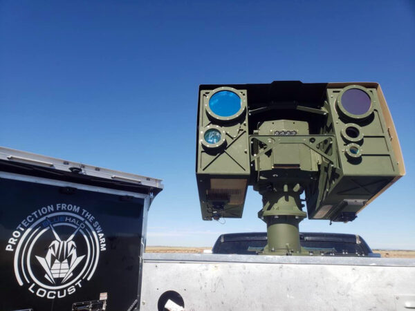
Featuring an advanced gimbaled EO tracking system designed for tracking various threat sets in cluttered or clear skies, the LOCUST TATS is made up of two main components: the fine tracking system (FTS) and the acquisition tracking system (ATS). The ATS is equipped with multiple camera payload options that have a wide field of view, aiding in early target identification and tracking, along with a targeting laser designed to highlight targets. The FTS module includes a powerful telescope, a laser rangefinder, and additional camera payload options.
Human-Machine Interface (HMI)
Supports external network interfaces, provides the capability to accept external cueing messages, and distributes video, time, space, position information (TSPI), and tactical information to higher echelon target tracking as compared to traditional pan/tilt gimbal solutions.
RF Cueing Sensor Interface and Overlays
“Plug-and-Play” capability with a wide variety of sensor types and RF bands.
Multi-target IR Search and Track Modes
Automated tracking capabilities that enable agile switching between targets in high density threat environments
High Bandwidth Tracking for Threat Identification
State-of-the-art, high-definition video gives decision makers the highest fidelity data to evaluate threats in complex air defense environments.
High Resolution 3-D Target Location Reporting
Microradian-class track data transmitted to a wide variety of C2 networks. Increased system combat effectiveness.
Integration Support for C2 Networks
Low-latency interfacing with C2 networks to receive and provide target cues, with ability to transmit video, track, and provide situational awareness data to improve capabilities.
Learn More About LOCUST TATS
Contact UsRapidly Deployable
All sensors are battery or solar powered and communicate over a wireless mesh network, allowing the system to be rapidly deployed and easily reconfigured without requiring any change in facility infrastructure.
Interoperable
ARGUS mesh communications networks are used to cross cue external systems through software or hardware interfaces, supporting integration with a single common operating picture.
Robust
ARGUS sensors are built to withstand harsh environments, and in the case of sensor failure, the wireless network self-heals to prevent any gaps in detection.
Multiple Sensor Types
ARGUS utilizes complimentary sensing modalities at AI/ML algorithms to fuse sensor data and enhance alert confidence.
Map-Based User Interface
ARGUSView is the software interface for on-site and remote monitoring of an ARGUS system, displaying all sensors and accessories in one common operating picture on a map-based interface.
Enterprise Services
ARGUS Enterprise enables cloud-based remote access, data archival and alert history, multiple user access levels, and real-time positioning of security personnel.
Learn More About ARGUS
Contact Us